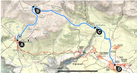
the HIKES
all hikes start off Agios Ioannis square or Petres
gps & cell phone compatible files available upon request (format .gpx .kml)
difficulty ratings: 1 Easy, 2 Moderate, 3 Difficult, 4 Very Difficult, 5 Experts Only
the difficulty ratings are based on the average hiker taking into account factors as
distance, time needed, terrain, elevation profile, cell phone network availability, heat, need of navigation skills and good sense of direction, dhow much is needed to carry (i.e. water, etc)
an easy hike in a remote area is given a higher rating an even higher if it exposed to heat (close to the sea)
always bear in mind that Lefka Ori is a demanding mountainous area with very limited spots for water replenishment, and mostly exposed to direct sun.

A. Kakos Poros
A lighthearted shaded afternoon hike to a balcony
overlooking South Cretan Sea, Agios Pavlos beach and
Agia Roumeli
Best sunset spot!
One way: Distance 1,5k - Hours 45' - Elevation Gain 0
- Elevation Loss 230m
1/5 Easy

B. Papakefala
Another lighthearted shaded hike to Papakefala summit (1015m) that may be combined with Kormokopos cave.
Short before the final climb to the summit you come to a nature's balcony with views to Eligia gorge and Agia Roumeli
One way: Distance 2,6k - Hours 1:15 - Elevation Gain
250 - Elevation Loss 40m
1/5 Easy

C. Kormokopos Cave
At two thirds of the Papakefala route you come to a path “fork” wherefrom you take the to the right hand side trail. Not long after you come to Kormokopos Cave.
Shaded, no water.
It may be combined with Papakefala
One way: Distance 3,3k - Hours 1:30 - Elevation Gain
320 - Elevation Loss 100m
Combined Agios Ioannis - Papakefala - Kormokopos -
Agios ioannis
Distance 8,5k - Hours 3:30 - Elevation Gain 450 -
Elevation Loss 450m
1/5 Easy

D. Kalos Poros Selouda Agios Pavlos Agia Roumeli
After you’ve past the village south east gate take the
tarmac road to your right and look for the red signs.
Make two -slightly off the way- stops to the chapels of
Agios Ioannis (left deviation) and Panayia (right
deviation). Both temples are built in the Venetian Era but that of Panayia, although it is smaller, it is more
impressive because there are several frescoes surviving
in good condition. The keys are usually hanging over the
gate.
Back to the trail you come to Koutelo Selouda (one of
the finest viewpoints in Crete at the edge of the cliff.
After a demanding descent you come to a tri-cross-trail.
Left goes to Marmara and Lykos (see next). You take
the right path to Agios Pavlos chapel (1040aC) and beach. Α little eatery there with cold beer, water and toilets. Follow the seaside trail to Agia Roumeli.
Distance 6k to Agios Pavlos + 4k to Agia Roumeli - Hours 4 - Elevation Gain 50 - Elevation Loss
850
2-3/5 Moderate+

E. Kalos Poros Selouda Marmara Lykos Loutro
Same as before until the tri-trail E4 junction where you turn left (point B). Following the seaside path you come to the beautiful -if not crowded- beach of Marmara. This is where the Aradaina gorge meets the sea! Taverna and sunbeds!
As there is no road to Marmara people come on boats from Sfakia (scheduled trips).
For your return you may take a boat to Sfakia but we suggest you walk to Lykos and Loutro. From Loutro you may catch the same boat that comes from Marmara to Sfakia or you may climb the sharp uphill trail to Anopolis.
Cumulative Distance and Elevation from Agios Ioannis to:
Point B: 4,6k, 1:45hrs, elevation gain 0 elevation loss 730
Marmara: 10,5k, 3:34hrs, elevation gain 100 loss 910
Lykos: 11,6k, 4:15hrs, elevation gain 160 loss 970
Loutro: 13,4k, 5hrs, elevation gain 250 loss 1060
Anopolis: 18k, 7:30hrs, elevation gain 900 loss 1133
Overall Difficulty 2-3/5 Moderate+

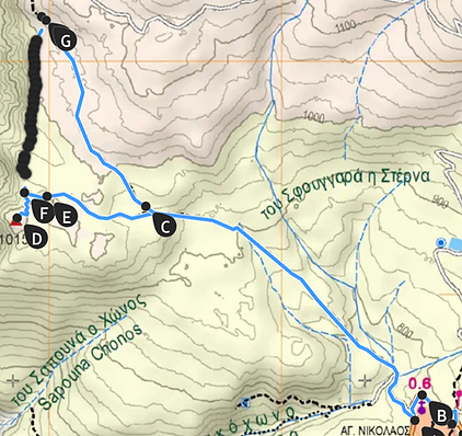
F. Krousia plateau - Drakolaki Cave
Direction north and uphill. Join the path to Krousia
plateau where you find the “mitato” (= stone-built
primitive creamery) of Georgedakis family (Antonis
Georgedakis and his wife Anna run Alonia guest house
whereas his senior father Yannis takes care of their
sheep and goats they keep in Krousia). Follows the short flat and shaded walk to Drakolaki cave that you may enter with care and a head light. Slippery inside the cave but beautiful. Fixed rope assist not to loose your legs. The cave has a length of 1900m and is richly decorated with stalagmites and stalactites, while it is very interesting to see the large quantities of sand. Only the first 400m of the cave is accessible.
A new slightly shorter path has been opened -easterly approach- with optional deviation to the old ruined castle (koules). It also avoids the land slide.
Distance to Krousia 3,5k + 2k to Drakolaki - Hours 3 - Elevation Gain 470 - Elevation Loss 130
2 /5 Moderate

G. The Old School Trail: to Anopolis via Aradaina village
We follow the old path villagers used to take to Anopolis,
before the bridge and the road were built (late eighties)
At Aradaina village we cross the canyon and climb up the opposite side. Via old paths we come to
Anopolis. One small deviation leads to Anopolis Koules
(=Turkish fort) that had visual contact with the koules of Agios Ioannis and the fort of Loutro. Almost nothing survives from the fort, apart from some wall foundations.
Distance to Aradaina 5,5k + 3k to Anoplolis - Hours overall 3 - Elevation Gain 120 - Elevation Loss 340
1-2/5 Easy +
H. Trail to Anopolis via Krousia and Dromatari Skala (north entrance to Aradaina george)
Uphill to Krousia plateau where from we follow the Kato Lakos trail under the overhanging cliffs of Mavri Kefala. After about 1,5 hour we cross the gorge of
Aradaina (north part) via the Diomatari Scala. Once on the other side after half hour we come to a dirt road that leads to Anopolis.
Distance 3,5k to Krousia (point B on the map) + 4,5 to Dromatari Scale (point C) + 3k to Anopolis - Hours 5 - Elevation Gain 450 - Elevation Loss 660
2-3 /5 Moderate with Difficult sections

I. Aradaina Gorge Crossing
(Agios Ioannis - Bridge - Marmara)
From Agios Ioannis we follow the old path to
Aradaina village wherefrom we descend to the
canyon bottom via the old stone path.
Trekking inside the canyon till the exit on the
majestic Marmara beach is an unforgettable
experience.
Aradaina is one of the most interesting gorges and
one of the longest ones (15km long). The old
Sfakians called it Faragas due to its size. This
characterization was later falsely used for
Samaria. The gorge actually starts from the root of
the peak Thodoris Korfi of the White Mountains
and specifically from the underground stream of
Drakolaki Cave. However, most people think that it
is only 7km long because the easiest way is to
reach it from Aradaina village, at the middle of the
gorge length.
From Marmara follow directions as per trail E.
On the way into the gorge, you will meet a deep
vertical pass where fixed ropes and two iron ladders has been placed.
Distance to Aradaina (B on the map) 5,5k + 6k the gorge crossing to Marmara - Hours 4,5 (3 in the
gorge)
2-3 /5 Moderate with Difficult sections

J. Livaniana and Lykos
Following the trail to Selouda we turn left on the
first dirt road we come across, that we follow for
almost 2k and until we spot the wooden sign post
that shows as the way to Livaniana. After about
another 2k on a harsh terrain we come to the
Aradaina canyon bottom (point C on the map)
where from we climb up on the opposite side. We
come to the abandoned village of Azogyres, the
old church of Agios Athanasios is the sole
remaining building.
Dirt road will lead us to Livaniana (taverna to be
found in the village but reported to be often
closed)
From Livaniana follow the descending trail to Lykos.
Alternatively short before you enter the village one can take the ascending trail to the left that after a while it splits either to Aradaina village or to Anopolis .
Distance to Livaniana 6k + 2k to Lykos - Hours 3+1 - Elevation Gain 140 - Elevation Loss 940
3-4 /5 Difficult with Very Difficlut sections

K. Zaranokefala trail
Agios Ioannis - Krousia - Zaranokefala 2139.
From the village we ascend to Krousia Plateau
where from we follow north west direction. Uphill
path will lead us to Dounavi spring (that waters the
village of Agios Ioannis) and further to the on-the-ground spring of Zarani. Water under a black
plastic cover. Caves aside offering good overnight
shelter. Short after we come to a land slide that we
ascend with care (and tiredness) to the col leading right to Zaranokefala summit (2139m)
Distance 8k - Hours 5 - Elevation Gain 1400 -
Elevation Loss 130
3-4/5 Difficult becoming Very Difficult towards the summit

L. Krousia to Pachnes 2453 (Zaranokefala
traverse)
In continuation of previous hike at the land slide we cross northbound to the cairn marking the landslide’s “exit” and by using our imagination and sense of direction (northeast) we come to the summit of Pachnes (2453m).
Distance from the land slide 3,5k. Sharp ascend at
the end. Very few (maybe 2 or 3) cairns showing
the way (planned to mark this trail in the near future). The landscape is amazing hiking through
dark grey rock formations, deep holes and
summits (Mesokefales, Gaidara, Mesa Tourloti)!
From the Village
Distance 11k - Hours 7 - Elevation Gain 1600 - Elevation Loss 400
3/5 Difficult

M. The Old Resin Tappers Way
We start following the trail to Papakefala and Kormokopos.
Before we come to the fork (as described in hikes B and C) at the spot where the water cistern is, we leave the marked path to the left aiming to the gorge. We walk slightly downhill in the beginning with no signs but it is easy to recogn the way leading to the gorge. Once in the gorge (Sapouna Chonos) the slope becomes sharper (at points very sharp) with rocky and uncertain terrain. We go on until we come to three consecutive stone marks (cairns). At this point we leave the gorge to the left (SE and then E) following the uphill easily recognised and marked trail. We move in dense pine forest till we come to a second gorge named Sfakohono. We cross Sfakohono and follow the obvious trail (SE direction) till we meet the very obvious Kalos Poros trail that we follow uphill to the village.
Distance 6k - Hours 3+ - Elevation Gain 300 -
Elevation Loss 400
2-3 /5 Moderate with Difficult sections
(the extended unmarked steep rocky terrain in the gorge of Sapouna Chonos)
N. Papakefala Kormokopos via Vang Connecting Cut
This is a shortcut to Papakefala and Kormokopos without having to return to the "trail junction" (point C on the map).
It is a newly opened and marked trail by Vangelis, thus we have named it after him!
Beautiful views along the way as it touches the cliff.
Round Trip Distance 6,5k - Hours 3,5 - Elevation Gain 420 -
Elevation Loss 420
Difficulty 2/5 Moderate

O. Elygias Gorge
From Kormokopos Cave we continue in the sharp downhill slope (very limited red dot marking) in dense forest with two to three exposed passages (slippery if wet) and a stone slide ... till we reach the bottom at the point named Fliskounias. From then on we continue walking on the gorge bed (difficult at parts but straight forward, till we reach the sea and the E4 Coastal Path.
Two choices ...
right towards Agia Roumeli
or
left towards Agios Pavlos (hike D back to the village) and further on to Marmara, Lykos, Finikas, Loutro (revert to hike E)
distance to the sea via Elygias Gorge 8k - Hours 4+ - Elevation Gain 350 - Elevation Loss 1130
4-5 /5 Very Difficult to Experts Only (section between points B and C requires expertise hiking skills )